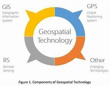
ADDIS ABABA- Geospatial Infor mation Agency (GI2) said it has given due emphasis to the utilization of geospatial information to attain environmentally sustainable development.
Tulu Besha (PhD), Director General at GI2, told The Ethiopian Herald geospatial information is now being utilized as an input for environmental monitoring and security. “Nowadays, with the rapid development of geospatial technologies, more attention is given to monitoring the environment and security in order to ad – dress the most pressing challenges related to land and wetland degradation, deforestation, natural disaster, etc.”
He also said that the Agency is striving to become competitive at continental level in utilizing geospatial information. Hence, it is utilizing airborne and terrestrial surveying as well as observation satellites for the acquisition of geospatial information in order to enhance its role for decision making in environmental management, security and other sectors.
According to him, the Institute has built capability in aerial photogrammetric surveying, processing, production, archiving as well as dissemination of photogrammetric data and products for stakeholders to support decision making process related to environmental management and security.
The geospatial information is supporting different stakeholders that are involved in agriculture, natural disasters, environmental management, natural resource management, land registration and good land governance, mapping, aeronautical charting and surveying activities, he stated.
He also said following the increasing number of population and urbanization, natural resources are com – promised without thinking the next generation. “So it is important to protect our natural resource such as forest, water, land and soil resources by creating linkage with the sustainable development program using geospatial information.” The Agency is also planning to build capability in airborne LiDAR surveying technology and end to end processing and production of LiDAR data.
The GI2’s workstations can serve as a national and regional hub for processing of various geospatial datasets, he said.
The Ethiopian Herald, December 20/2018
BY ESSEYE MENGISTE


