


National parks are vital sanctuaries for wildlife, serving as crucial habitats for a diverse array of species. Across Africa, where iconic wildlife populations thrive, technology has emerged as a powerful tool for safeguarding animals and supporting effective conservation efforts. This article explores the application of technology in African national parks and highlights some of the best practices employed by countries in the region.
African countries have embraced smart surveillance systems as an effective means of combating poaching and ensuring the security of national park boundaries. These systems utilize a combination of technologies such as drones, thermal imaging cameras, and advanced sensor networks to monitor wildlife movements, detect potential threats, and track poachers. By employing real-time monitoring and data analysis, park authorities can respond swiftly to incidents and protect vulnerable animal populations.
One notable example is Kenya’s Ol Pejeta Conservancy, which utilizes aerial drones equipped with thermal imaging cameras to patrol vast areas, identify poaching activities, and gather vital intelligence for anti-poaching operations. This technology has significantly contributed to the protection of endangered species like rhinos and elephants.
The use of GPS tracking and collaring devices has revolutionized wildlife monitoring and research. By fitting endangered animals with GPS collars, conservationists can collect critical data on their movements, behavior, and migration patterns. This information helps identify important habitats, migration corridors, and areas prone to human-wildlife conflict.
Namibia’s Etosha National Park has successfully implemented GPS tracking technology to monitor black rhinos, a critically endangered species. The collars provide real-time location updates, enabling rangers to monitor their movements and respond swiftly to any potential threats, such as poaching or habitat disturbances.
Geographic Information Systems (GIS) have become indispensable tools for managing and analyzing vast amounts of spatial data in national parks. GIS technology allows park managers to map wildlife populations, habitat distribution, and land-use patterns. By integrating various datasets, such as satellite imagery, climate data, and animal tracking information, park authorities can make informed decisions regarding conservation strategies and resource allocation.
South Africa’s Kruger National Park employs GIS to monitor animal populations, track habitat changes, and identify areas of concern. This technology enables park officials to implement targeted conservation interventions and assess the effectiveness of their initiatives in real-time.
Mobile applications have emerged as powerful tools for engaging local communities in wildlife conservation. African countries have developed apps that provide information on nearby national parks, species identification guides, and reporting mechanisms for wildlife sightings and poaching incidents. These apps foster a sense of ownership and empower communities to actively participate in conservation efforts.
Uganda’s Uganda Wildlife Authority launched the “Uganda Wildlife Explorer” mobile app, which serves as an interactive guide to the country’s national parks. It offers educational content, maps, and features for reporting wildlife crimes, promoting responsible tourism, and enhancing community involvement in conservation initiatives.
As technology continues to advance, its integration into national park management in African countries offers immense potential for safeguarding wildlife populations and ecosystems. The application of smart surveillance systems, GPS tracking and collaring, GIS, and community engagement through mobile applications exemplify the best practices being implemented across the region. By harnessing these technologies, African countries are enhancing their ability to combat poaching, monitor wildlife, and engage local communities in wildlife conservation. These efforts contribute to the long-term preservation of Africa’s iconic and ecologically significant biodiversity.
Ethiopia is a country renowned for its rich biodiversity and unique wildlife. With numerous endemic species, such as the Ethiopian wolf, Walia ibex, and Gelada baboon, it is crucial to implement effective conservation measures to protect these animals and their habitats. In recent years, GPS tracking systems have emerged as a valuable tool for monitoring and safeguarding endemic animals. This article explores how GPS tracking technology is being employed in Ethiopia to enhance wildlife conservation efforts.
GPS tracking systems employ a network of satellites to determine the precise location of an object or individual. In the context of wildlife conservation, GPS collars are commonly used to track and monitor animals. These collars are equipped with GPS receivers, allowing researchers to collect real-time location data, movement patterns, and other important behavioral information.
GPS tracking systems have revolutionized wildlife conservation research in Ethiopia. By providing accurate and continuous location data, researchers can gain valuable insights into animal behavior, migration patterns, and habitat usage. This information aids in understanding the ecological needs of endemic species, identifying critical habitats, and developing effective conservation strategies.
Endemic animal populations in Ethiopia often face numerous threats, including habitat loss, poaching, and human-wildlife conflict. GPS tracking systems play a pivotal role in monitoring the movements and survival of endangered species. By tracking their movements, conservationists can identify potential risks and take proactive measures to mitigate threats.
Human-wildlife conflict is a significant challenge in many parts of Ethiopia. As human populations expand and encroach upon natural habitats, conflicts arise between humans and endemic animals. GPS tracking systems help identify high-risk areas where such conflicts occur frequently. This knowledge allows conservationists and local communities to implement strategies that minimize human-wildlife conflict, such as implementing better livestock husbandry practices or establishing buffer zones.
Poaching remains a grave threat to the survival of endemic species in Ethiopia. GPS tracking systems enable real-time monitoring of animal movements, allowing rapid response to potential poaching incidents. If an animal’s GPS collar signals unusual or suspicious behavior, conservation authorities can investigate and intervene promptly, increasing the chances of apprehending poachers and protecting endangered wildlife.
GPS tracking systems also contribute to conservation education and awareness initiatives. The data collected through these systems can be shared with the public through interactive maps and online platforms, engaging local communities and raising awareness about the importance of protecting endemic species. By involving local communities in conservation efforts, GPS tracking systems foster a sense of ownership and responsibility for the welfare of these animals.
GPS tracking systems have become invaluable tools in the conservation of endemic animals in Ethiopia. By providing accurate location data, these systems aid in understanding animal behavior, identifying critical habitats, and mitigating threats such as human-wildlife conflict and poaching. Furthermore, GPS tracking systems foster public engagement, empowering local communities to actively participate in wildlife conservation efforts. As technology continues to advance, the application of GPS tracking systems in safeguarding endemic animals will undoubtedly contribute to the long-term preservation of Ethiopia’s unique biodiversity.
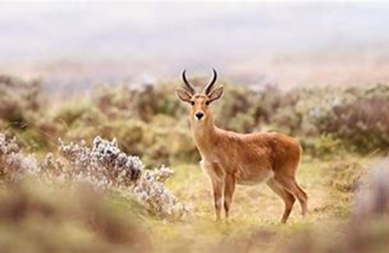
Simien Mountains National Park announced that it has introduced GPS tracking system to monitor and safeguard the endemic Red Fox population in the park.
The Red Fox Conservation Program Coordinator at the Park, Getachew Assefa told ENA that this tracker has been deployed in collaboration with the Ethiopian Wildlife Protection Authority and international partner organizations.
The system introduced is the Collar GPS tracker wherein GPS-enabled collars are attached to the necks of 8 red foxes with forty family members. The tracker enables to trace movements of the foxes as they search for food and navigate through potential threats, he said.
By utilizing the system, we can track the distances covered by the foxes each day in their pursuit of sustenance as well as the dangers they encounter along the way, Getachew elaborated. As a pilot project last year, GPS trackers were employed on two red foxes, leading to the acquisition of crucial information when these animals faced life-threatening situations, including death and severe injuries.
The Collar GPS tracker also facilitates the tracking and controlling of illegal poaching activities. According to the program coordinator, the red foxes primarily inhabit mountainous regions above an elevation of three thousand meters.
Covering an expansive area of four hundred twelve square kilometers, Simien Mountains National Park is not only the largest national park in Ethiopia but also a UNESCO designated international heritage site.
It encompasses the highest portions of the Simien Mountains, including Ras Dashan, the highest peak in Ethiopia. The park serves as a sanctuary for numerous endangered species, including the Ethiopian Wolf and the Walia Ibex, a unique wild goat found nowhere else in the world.
Additionally, the Simien Mountains Park is home to the Gelada Baboon and the caracal, a remarkable feline species. Over 50 bird species, including the bearded vulture with its impressive 3-meter wingspan, inhabit the park.
Ethiopia is a country renowned for its rich biodiversity and unique wildlife. With numerous endemic species, such as the Ethiopian wolf, Walia ibex, and Gelada baboon, it is crucial to implement effective conservation measures to protect these animals and their habitats. In recent years, GPS tracking systems have emerged as a valuable tool for monitoring and safeguarding endemic animals. This article explores how GPS tracking technology is being employed in Ethiopia to enhance wildlife conservation efforts.
Endemic animal populations in Ethiopia often face numerous threats, including habitat loss, poaching, and human-wildlife conflict. GPS tracking systems play a pivotal role in monitoring the movements and survival of endangered species. By tracking their movements, conservationists can identify potential risks and take proactive measures to mitigate threats.
Human-wildlife conflict is a significant challenge in many parts of Ethiopia. As human populations expand and encroach upon natural habitats, conflicts arise between humans and endemic animals. GPS tracking systems help identify high-risk areas where such conflicts occur frequently. This knowledge allows conservationists and local communities to implement strategies that minimize human-wildlife conflict, such as implementing better livestock husbandry practices or establishing buffer zones.
BY LAKACHEW ATINAFU
The Ethiopian Herald March 22/2024