The projection and perspective of the continents particularly on the World Map are subject of controversy among cartographers. The distortion of the size of some continents on the World Map as well as the perspective that keeps some continents on the “up” and the rest on the “lower” part of the globe are the epicenter of debating among scholars.
Though it appears as a merry-go-round debate for some, a great deal of scholars treats the topic in the context of tackling the entrenched oppressor/oppressed relations. Both the map and the globe tacitly serve to define power relations between the Global North and Global South if you like.


The CNN published an article by Sophie Morlin-Yron in March 2017 entitled ‘What’s the real size of Africa? How Western states used maps to downplay size of continent’. (Why do Western maps shrink Africa? | CNN)
According to Morlin-Yron, Geert de Kremer (Gerardus Mercator) projection of the world map is highly misleading. The said projection of the map is the one which is widely in use even in their Google map. And our long-held concept of the map and globe is rooted in the 16th C Mercator projection.
“Mercator initially made globes. Later transferring his map from a three-dimensional curved surface to a flat sheet of paper was problematic. Taking the equator as the logical map center left big, confusing gaps near the poles,” argues Morlin-Yron.
The Euro-centric view is responsible for shaping our perspective as far as the map and the globe are concerned. We have taken for granted both the distortion and the nominal ‘top-down’ perspective of the continents.
Isn’t it stunning to read that a fair projection of the map of Africa can comfortably fit a landmass as big as three times the size of Canada? But on the map, Canada is projected as larger, may be appearing close to the size of Africa.
There isn’t dispute in the distortion of the size of Africa and may be others as well. One could argue that maps themselves have evolved historically at different civilizations and by various cartographers, and distortion is unavoidable. But, the thing is, maps and their representations go beyond demonstrating geographical boundaries and landscapes.
Farish A. Noor (PhD) (an Associate Professor), a scholar who is said to have been collecting and interpreting old maps for three decades, had this to say in his article published in 2015: “By reading maps I mean that the map is never simply a chart or a plan of territory, but also a statement (of intent or ambition) that can be interpreted and understood.”
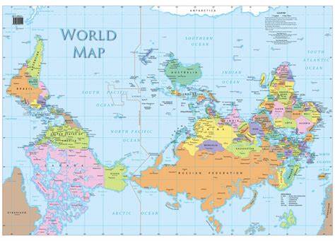
It is a little less than half-a-century since McArthur’s Universal Corrective Map has brought a new perspective. It puts the map “upside down.” In February 2014, Nick Danforth published an article that goes with a title: ‘How the north ended up on top of the map”. Please click the link for more: http://america.aljazeera.com/opinions/2014/2/maps cartographycolonialismnortheurocentricglobe.html
Why raising this topic now?
The diplomatic week and exhibition at the Science Museum in Addis Ababa have once again brought the topic to the attention of this writer.
The exhibition launched on Jan 11, 2024 goes with a catchphrase; “From an African hub to the world.” The catchphrase attempts to epitomize the role Ethiopia has been playing in fulfilling its international commitment aside from serving as the diplomatic capital of Africa. Ethiopia’s role has been seamless particularly for the maintenance of international peace. Emperor Haile Selassie had seen the looming danger that would engulf the world while he urged members of the League of Nations to be true to their own covenants and morality in his appeal at in 1936. The League neither safeguarded the sovereignty of Ethiopia nor did it prevent another round of World War.
After the end of WWII, Ethiopia became the only independent African founding member of the UN. Ethiopia under the blue helmet of the UN proved its commitment to safeguarding world peace. It also championed the unity of Africa and played a forerunner role in founding the OAU, the present day AU. Ethiopia’s health professionals helped the fight against the deadly Ebola in the West Africa. Ethiopian continued connecting Africa to the rest of the world and delivered emergency kits to fellow Africans in times that other airliners had banned flights. Over and beyond, the ancient country, Ethiopia, serves as a symbol of freedom to all the oppressed.
Visualizing Ethiopian diplomacy
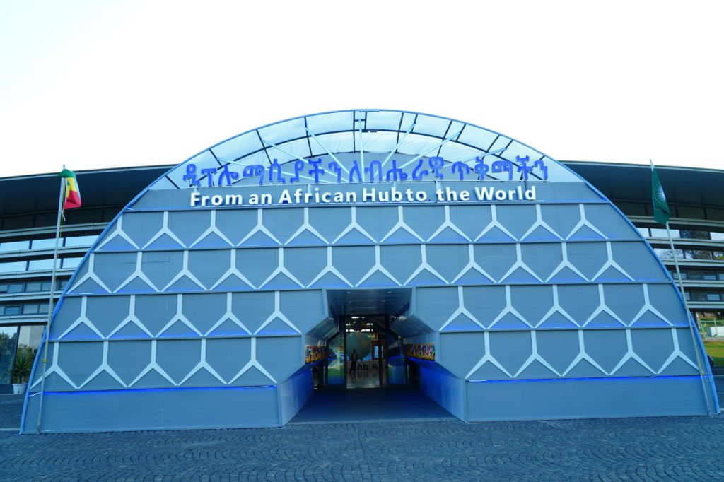
The gate of the exhibition at the Science Museum imitates the sentimental building of the Ministry of Foreign Affairs. The design incorporates other features as well.
As can be seen in the picture here, the semi-circle (arch) structure represents the globe. It depicts the global nature of Ethiopian diplomacy. And there are seven rays at the interior part of the arch (intrados) which shows Ethiopia’s extensive diplomatic relations that spans across all the continents. The front design of the gate features the unique pattern of the Ministry’s building. Each layer is interconnected with hexagonal structures. The design works of the building that were completed in 1964 apparently symbolize the English letter “Y” and “K’. As this writer has heard from a senior diplomat, the “K” and “Y” stand for the initial letters of the given names of then Minister of Foreign Affairs, and Minister of Finance (Ketema Yifru was Minister of Foreign Affairs, Yilma Deressa served as Minister of Finance). The duo cooperated in the construction of the Headquarters’ building in their respective capacities, according to the diplomat. As art work is always subject to multiple interpretations, it is given that there could be other symbolism embedded it.
The thing is, as you walked inside, passing the giant magnificent gate; you would be greeted by a huge rotating Globe. The Globe has to do with Ethiopia’s diplomacy that is first depicted by the arch and the rays at the gate. Here you will see the sites of the Ethiopian diplomatic missions on the globe represented by a blinking light.
Here lies the crux of this piece of writing. In this writer’s view, the continent, Africa, appeared visibly large on the globe. The vastness of Africa is reflected on the Globe. And one would say that it creates a good impression on any keen spectator. The positive impression on children would also be huge. There is a power in representation of course.
The colonial period as, V.Y. Mudimbe, hypnotized (see The Invention of Africa), did not only organized and arranged the modes of production and physical space, it also formatted the minds of the people.
Yet, African children and youths of this digital era should get enough opportunity to see the world anew. And freeing the mind from the domination must involve understanding ourselves and the world around us in our own standards. The entrenched concepts and practices…need to be deconstructed.
BY WORKU BELACHEW
THE ETHIOPIAN HERALD THURSDAY 25 JANUARY 2024


